A topographic map does not tell you what a site looks like. It tells you where the water is already going, and water was moving across that ground long before anyone drew a property line on it. Learning to read a topographic map for site design is mostly learning to see drainage in a set of curved lines, then placing a building so it works with that drainage instead of fighting it.
This matters for two reasons. On the exam, the 2026 ExAC Preparation Guide lists objective 2.3.2, explain data obtained from a land surveyor's drawing and a topographical map, and objective 2.2.2, apply the principles of grading and storm water management to site design. In practice, the National Building Code makes siting a compliance question, not just a design preference.
What a contour line actually is
A contour is a line joining points of equal elevation. Every point along the 103.50 contour sits at exactly 103.50 metres above the project datum. That is the whole definition, and three consequences follow from it that carry most of the exam value.
- Contours never cross. A single point cannot have two elevations. If you see lines crossing, you are looking at an overhang, a retaining wall, or a drafting error.
- Contours close on themselves. They either loop within the drawing, forming a hill or a depression, or they run off the edge of the sheet.
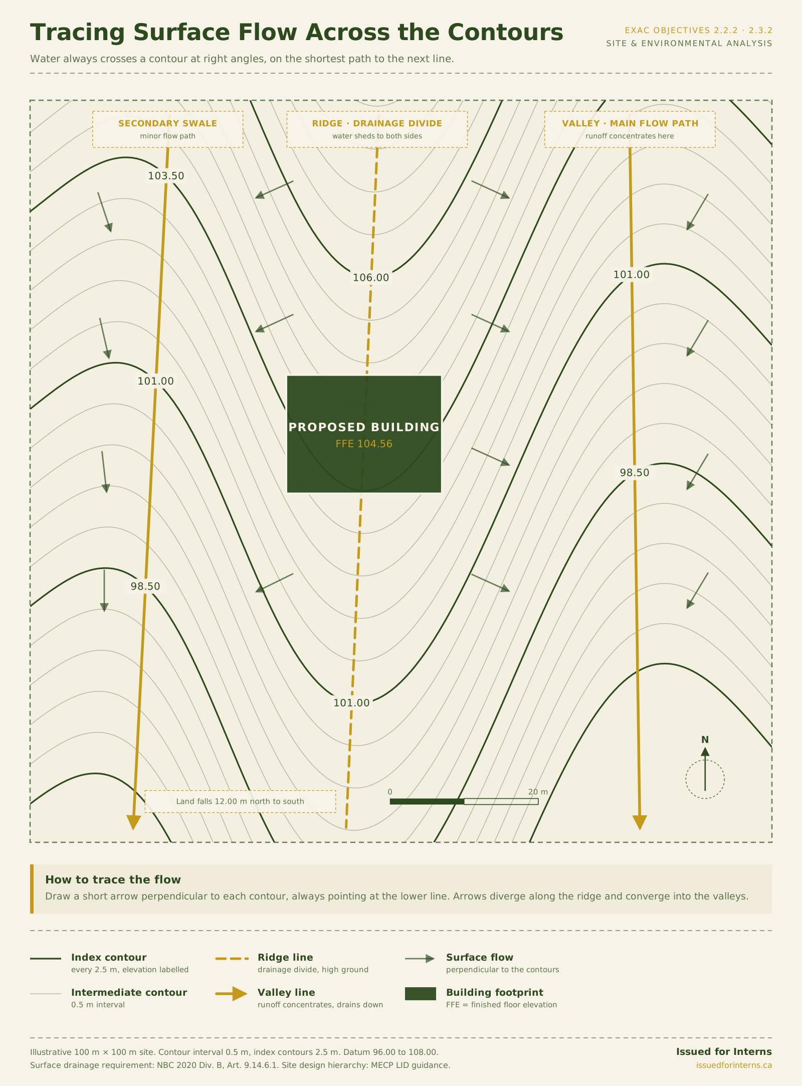
- Water always crosses contours at right angles. Water takes the steepest available path, and the steepest path from any contour is the shortest one to the next contour, which is the perpendicular.
Check the contour interval before you read anything else. Urban site surveys in Canada are typically drawn at 0.25 m or 0.5 m intervals, with a heavier index contour every fifth line carrying the elevation label. A map at 0.5 m and a map at 5 m can show identical line patterns and describe completely different pieces of ground.
The rule of Vs: is that a ridge or a valley
This is the single distinction candidates get backwards, and it is worth committing to memory in a form you cannot scramble under time pressure.
Where contours bend into a V or a U, the direction the point faces tells you which landform you are looking at:
- Valley. The V points uphill, toward higher ground, toward the upstream end. A watercourse or swale runs down the centre of it.
- Ridge or spur. The V points downhill, away from the high ground.
The reason is worth understanding rather than memorising. In a valley, the ground at the centre line is lower than the ground on either side, so a given elevation is reached further upstream in the middle than at the flanks. The contour is dragged upslope. On a ridge the reverse is true, and the contour is pushed downslope.
The visual trap is that a ridge on paper often reads as a trough, because the contours dip toward the bottom of the sheet. Ignore the shape and read the numbers. Find two labelled index contours, establish which way the ground rises, and the Vs resolve immediately.

Spacing tells you slope
Contours close together mean steep ground. Contours far apart mean flat ground. You can put a number on it: slope equals the contour interval divided by the horizontal distance between the two lines. Contours at 0.5 m spaced 5 m apart describe a 10 percent slope.
A few thresholds are worth carrying into the exam room, because they are the numbers that turn a site design question into a costing or accessibility question:
- Roughly 2 percent is the practical minimum for positive surface drainage across soft landscaping.
- Barrier free routes are constrained well below the slopes that ordinary walkways tolerate, which means steep ground pushes accessible entrances, parking and paths toward the flattest part of the site. That is objective 2.2.4 arriving through the back door of a topography question.
- Ground steeper than about 15 to 20 percent starts to demand retaining structures, and retaining structures are where site budgets go to die.
Where the water goes, and where the building should not
Trace flow by drawing short arrows perpendicular to each contour, always pointing to the lower one. Do it across the whole site and the drainage pattern appears on its own. Arrows diverge along ridges. Arrows converge into valleys. The ridge line is a drainage divide: rain falling on one side leaves the site by one route, rain falling a metre away on the other side leaves by another.
See it happen instead of just reading it. The model below runs the same rule live on a procedurally generated site: rain crosses every contour at a right angle, diverges off the ridge, and concentrates into the valley exactly as the arrows above predict.
- Droplets in motion
- 0000
- Wetted surface
- 0.0%
- Elapsed
- 0.0s
A procedurally generated site at 1:200, contoured at thirteen intervals. Drag to orbit, drop the intensity to see individual droplets, or hit "New terrain" to try a different ridge-and-valley layout.
That divide is the most valuable line on the drawing. A building placed on or near it sheds water in both directions and receives almost no upslope catchment. A building placed in a valley bottom sits at the point where every drop on the site has already been collected and concentrated, on soil that is wet more often, for longer, with the poorest bearing capacity on the property.
Soil is the second half of that judgement. The official guide's own sample question under objective 8.2.1 asks candidates to rank clay, peat, silty sand and clean gravel by drainage capacity, and the ordering runs clay, peat, silty sand, clean gravel from lowest to highest. Valley bottoms are exactly where the fine grained material and the organics accumulate, so the worst drainage and the highest water concentration tend to arrive together.
The Code is direct about the consequences. NBC 2020, Division B, Article 9.14.6.1 requires that the building be located, or the building site graded, so that water will not accumulate at or near the building and will not adversely affect adjacent properties. Read the sequence. Locating comes first, grading second. And the obligation extends past the property line, which is the part candidates forget: solving your drainage by pushing water onto the neighbour is not a solution. If you have not yet tabbed your code book, our guide to tabbing the NBC 2020 for the ExAC walks through exactly where a lookup like this belongs.
There is a durability argument too. National Research Council field research on basement wall performance found that an initial 5 percent positive grade sloping away from the wall, built to good practice, had reverted to a negative grade sloping back toward the wall within a single year, purely through soil subsidence. Grading is not permanent. Siting is. A building placed on high ground is still on high ground after the backfill settles.
Disturb the site as little as possible
Objective 2.2.2 asks you to apply the principles of grading and storm water management to site design, and the word order there is deliberate. Grading is a design tool, not a repair.
Ontario's Ministry of the Environment, Conservation and Parks sets out a stormwater control hierarchy that begins with better site design and pollution prevention, then retention and infiltration, then filtration through low impact development practices, and only then conventional end of pipe controls. The cheapest and most effective move is the first one: choose a footprint that preserves the existing drainage pattern so there is less runoff to manage in the first place.
In practice that means working the building across the contours rather than through them, keeping the footprint out of the natural flow path, balancing cut and fill so soil is not trucked off site, and leaving pervious ground intact where the water already infiltrates. Every one of those decisions reduces earthworks, and earthworks show up in the construction stage of a life cycle assessment as fuel burned on excavators and haul trucks. Our guide to life cycle assessment and sustainability covers how those early phase choices propagate through the rest of the carbon picture.
The regulatory direction is moving the same way. Ontario's draft Low Impact Development guidance proposes a runoff volume control target based on the 90th percentile rainfall event, roughly 23 to 32 mm depending on where in the province the site sits, retained on site rather than discharged. It remains voluntary draft guidance, so do not describe it as a requirement in a short answer, but it tells you which way the ground is shifting.
Something close to this: the footprint sits on the ridge, which sheds to both sides and takes no upslope catchment, avoids the valley where flow concentrates and bearing is poorest, and crosses the fewest contours so cut and fill balance without altering the existing drainage pattern. That is four defensible points in two sentences, and it maps onto the way the objectives are written. If the question also mentions a neighbouring property, add the 9.14.6.1 obligation not to adversely affect it. Markers notice a Code reference used correctly.
For how this fits alongside the rest of Section 1, see our breakdown of what each ExAC section covers, and work the site analysis items in the free Section 1 practice questions under time.
Study Section 1 properly
Site and environmental analysis is one of thirteen themes, and the exam gives you roughly 90 seconds a question across all of them. The ExAC Study Guide covers every theme cross referenced to the official sources, with scenario based questions and full reasoning on each answer.
Get the ExAC Study Guide ($300 CAD)Sources
- ExAC 2026 Preparation Guide, Appendix 1 (objectives 2.2.1, 2.2.2, 2.2.4, 2.3.2, 8.2.1) and Appendix 2 (sample questions). Committee for the ExAC.
- National Building Code of Canada 2020, Division B, Article 9.14.6.1. National Research Council of Canada.
- Canadian Handbook of Practice for Architects, 3rd Edition, 2020. Royal Architectural Institute of Canada.
- Low Impact Development Stormwater Management Guidance Manual, draft 2022, and Stormwater Management Planning and Design Manual, 2003. Ontario Ministry of the Environment, Conservation and Parks.
- Performance of Thermal Insulation on the Exterior of Basement Walls, Construction Technology Update No. 36, 1999. National Research Council of Canada, Institute for Research in Construction.
- Flood Resilient Design of New Residential Communities, CSA W204:19. CSA Group.